
Rockland County ZIP Code Coverage
The county’s 2026 Reference Guide supplies the postal-place list below. The Post Office column repeats that documented postal-place label, not an independently confirmed station name. A ZIP code directory is a mailing reference, so its areas should not be mistaken for legal municipal limits. The list is still valuable because it identifies the postal name to verify before moving to a parcel map, town assessor, clerk, or archive.
| ZIP | Areas Covered | Post Office | Notes |
|---|---|---|---|
| 10954 | Bardonia and Nanuet | Bardonia / Nanuet postal place | One ZIP serves both listed places. |
| 10913 | Blauvelt | Blauvelt postal place | County guide postal-place entry. |
| 10920 | Congers | Congers postal place | County guide postal-place entry. |
| 10923 | Garnerville | Garnerville postal place | County guide postal-place entry. |
| 10927 | Haverstraw | Haverstraw postal place | County guide postal-place entry. |
| 10931 | Hillburn | Hillburn postal place | County guide postal-place entry. |
| 10952 | Monsey | Monsey postal place | County guide postal-place entry. |
| 10956 | New City | New City postal place | County seat mailing place. |
| 10960 | Nyack; Palisades Mall Postal Store in West Nyack | Nyack / Palisades Mall Postal Store | Postal label can include the West Nyack store. |
| 10962 | Orangeburg | Orangeburg postal place | County guide postal-place entry. |
| 10964 | Palisades | Palisades postal place | County guide postal-place entry. |
| 10965 | Pearl River | Pearl River postal place | County guide postal-place entry. |
| 10968 | Piermont | Piermont postal place | County guide postal-place entry. |
| 10970 | Pomona | Pomona postal place | County guide postal-place entry. |
| 10974 | Sloatsburg | Sloatsburg postal place | County guide postal-place entry. |
| 10976 | Sparkill | Sparkill postal place | County guide postal-place entry. |
| 10977 | Spring Valley | Spring Valley postal place | County guide postal-place entry. |
| 10980 | Stony Point | Stony Point postal place | County guide postal-place entry. |
| 10901 | Suffern and the surrounding Ramapo mailing area | Suffern postal place | Broader than the incorporated village. |
| 10982 | Tallman | Tallman postal place | County guide postal-place entry. |
| 10983 | Tappan | Tappan postal place | County guide postal-place entry. |
| 10984 | Thiells | Thiells postal place | County guide postal-place entry. |
| 10986 | Tomkins Cove | Tomkins Cove postal place | County guide postal-place entry. |
| 10989 | Valley Cottage | Valley Cottage postal place | County guide postal-place entry. |
| 10993 | West Haverstraw | West Haverstraw postal place | County guide postal-place entry. |
| 10994 | West Nyack | West Nyack postal place | Separate from the 10960 mall postal-store listing. |
Postal coverage sits inside a county with five towns, 18 villages, and 174 square miles of land. The 2026 guide reports a 2020 Census population of 338,329, but its town figures and the current Census QuickFacts page use different dates. ZIP labels should therefore be used for mail and search routing, not as a stand-in for a current population count or a municipal boundary map.
Twenty-six ZIP codes appear in the guide’s Rockland postal-place table. The individual labels above should be read with their notes, especially 10954, 10960, and 10901. A delivery ZIP narrows a search, but it does not show who is present at an address or which government office holds a record.
Note: Check the guide’s postal-place entry against USPS for the complete delivery address, including any apartment or other unit detail.
Rockland County ZIP Code Postal Places
Three local examples show why postal geography needs a second check. ZIP 10954 covers both Bardonia and Nanuet. ZIP 10901 is associated with Suffern and a broader Ramapo mailing area. ZIP 10960 can appear with Nyack and with the Palisades Mall Postal Store in West Nyack. Those names are useful search terms, but they are not interchangeable town or village identities.
Rockland has five towns and 18 villages. A road may cross a town, a village may sit within a town, and one ZIP can cover several communities. Keep the postal city and ZIP in one column of research notes, then record the municipal result, parcel identifier, and street spelling separately. That separation helps prevent a request from being sent to the wrong municipal assessor, clerk, Justice Court, or marriage-license office.
Rockland County ZIP Code Delivery Check
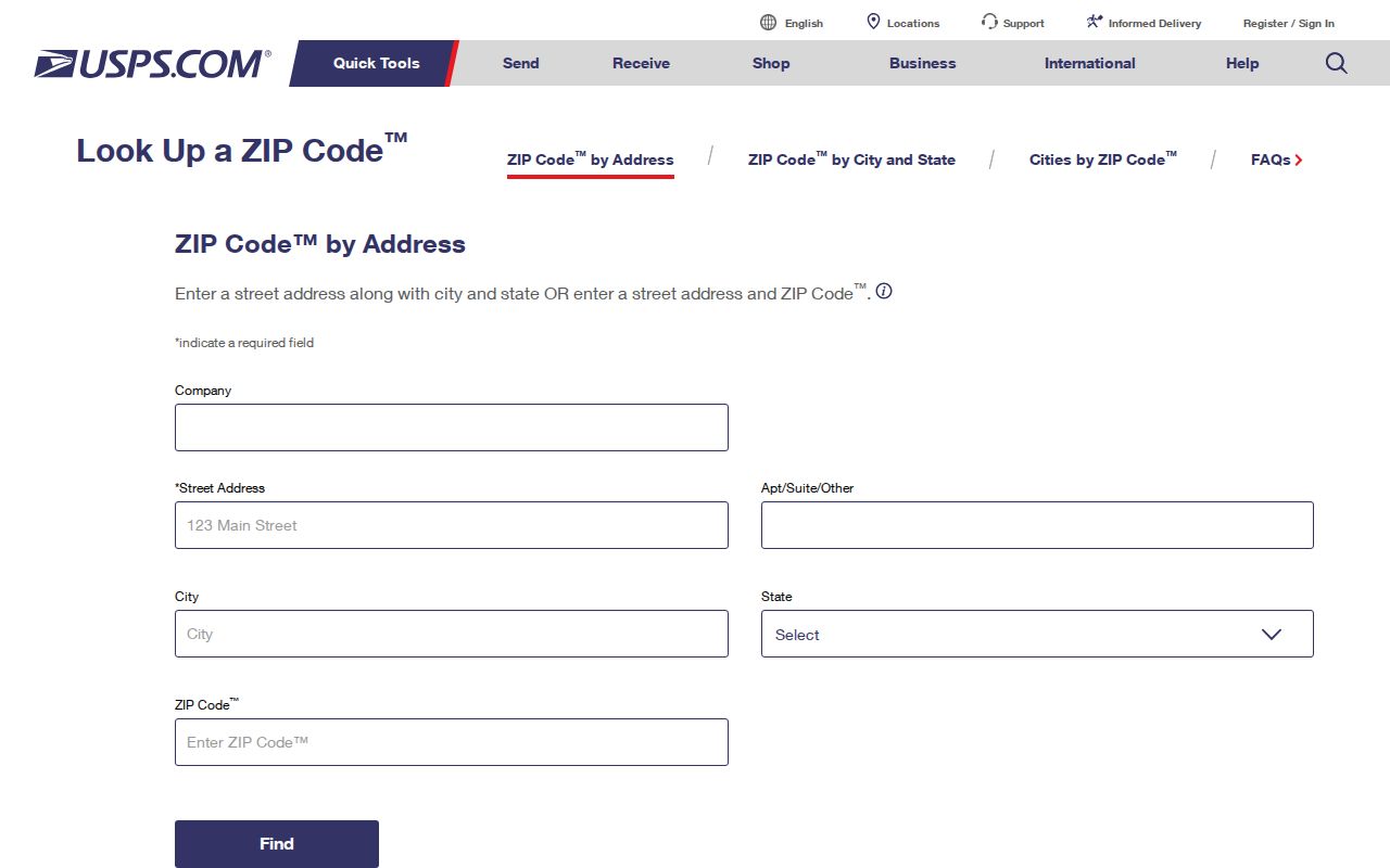
The USPS ZIP Code Lookup is the official delivery-validation step. Its By Address form accepts a company name, street address, apartment or suite detail, city, state, and ZIP Code. It also offers a city-and-state route and a Cities by ZIP Code route. USPS recommends a street address and unit number when more than one result may match, and it notes that a ZIP response does not establish that a person or company is at the address.
| Company | Optional By Address form field for a delivery search. |
|---|---|
| Street Address | Preferred input for a specific delivery location. |
| Apt/Suite/Other | Add the unit detail when it distinguishes matching addresses. |
| City and State | Inputs for address validation or the City and State lookup. |
| ZIP Code | Input for address validation and the Cities by ZIP Code option. |
The USPS address lookup source displays the address, city, state, and ZIP controls used for postal validation.
Save the returned postal wording with the date of the check. Use it to correct a delivery label before starting a municipal record search, not as evidence of occupancy, ownership, or legal jurisdiction.
Note: USPS validates a delivery label but leaves municipal, parcel, ownership, and occupancy questions to other records and custodians.
Finding Residents by Rockland County ZIP Code
A ZIP code directory supports a narrow, lawful research workflow, but Rockland has no confirmed countywide assessor owner-name portal or documented public GIS ZIP filter. Start with the whole address whenever possible. USPS validates the mailing details; Rockland GIS then identifies the parcel and municipality through its documented address or Tax ID search. The municipal assessor is the authority for assessment data, and the appropriate clerk or archive holds other record classes.
- Enter the complete street address and unit detail in the USPS tool to confirm the postal city and ZIP code.
- Search the Rockland GIS Portal by the documented address or Tax ID route to locate the parcel and municipal setting.
- Record the municipality, situs address, Tax ID, and postal label as separate facts before contacting an assessor, town or village clerk, or the County Clerk.
- For a personal voter-registration question, use the state form only with the information and purpose it requires. For another existing public record, contact the proper custodian rather than asking an agency to create a ZIP-wide people list.
- After a ZIP narrows the place, use the Rockland County street directory for the address-by-address record sequence.
A property record may name an owner, while a postal lookup only validates delivery data. Neither source alone confirms a current resident. Keep the question tied to the type of record being checked, and compare dates before treating two matching names as the same person.
Rockland County ZIP Code Parcel Routing
The Rockland GIS Portal is the bridge between a mailing address and local records. County guidance documents address and Tax ID searches, and the portal carries parcel, municipal-boundary, road, district, historic-resource, land-use, aerial, and other layers. Its map can orient a researcher to a parcel and town, but the county warns that the data are not warranted for completeness, accuracy, or usefulness. Confirm assessment facts with the relevant town assessor.
The Rockland GIS parcel viewer source shows the county mapping portal used to move from an address to a parcel context.
Use the parcel result to route the next question. A deed or mortgage question goes to the County Clerk; a historic tax-map question may require the individual town or Archives Building S; an assessment question belongs with the applicable municipal assessor. Do not convert an owner mailing address into a claim about who occupies the situs address.
Address flow: full address and ZIP → USPS delivery validation → Rockland GIS parcel and municipality → proper local custodian → dated record review.
Rockland County ZIP Code Custodian Handoff
Once GIS identifies the municipality, direct the question to the office that keeps that class of record. Assessment authority is municipal, so a parcel-card question goes to the relevant town assessor. A local town or village clerk is the first vital-record and marriage-license route. Local Justice Courts hold their own local civil, traffic, small-claims, and possession files. The ZIP code helps begin the routing, but the parcel and municipality decide the handoff.
The Rockland County Clerk is the county recording and court-record hub for land records, maps, naturalizations, and other filed material. For older county records, the Clerk’s Archives Building S in Pomona may be the needed access channel. A record can have an online index but an on-site paper file, so retain the ZIP and mailing label as context while requesting the actual record from its custodian.
Rockland County ZIP Code Voter Fields
The official NY Voter Lookup includes Rockland as a county option and has visible County, Last Name, First Name, Date of Birth, and ZIP Code fields. It requires cookies and JavaScript and is designed for a person to check registration, poll-site, and mail-ballot information. It is not a browsable countywide directory, and the result should be read as registration information rather than proof of current physical presence.
| County | Select Rockland for the county portion of the search. |
|---|---|
| Last Name | Visible form field for the registered voter’s surname. |
| First Name | Visible form field for the registered voter’s given name. |
| Date of Birth | Visible form field in MM/DD/YYYY format. |
| ZIP Code | Visible form field used with the other registration details. |
The Rockland Board of Elections maintains the local voter database and is the local office for a question the statewide lookup cannot answer. Election-law requests have their own lawful-purpose rules, and a request for voter-registration data must state an elections purpose. Ballot choices are not public.
Rockland County ZIP Code Boundary Limits
ZIP code, ZIP+4, and municipal boundaries each describe something different. A ZIP is the main delivery area. ZIP+4 is the added delivery detail for a smaller segment of that area. A PO-box ZIP is used for postal boxes rather than a geographic residence area, while a unique ZIP is assigned for a single organization or delivery purpose. A carrier route groups delivery stops and is not a legal boundary. The research did not confirm a Rockland PO-box-only ZIP or unique ZIP, so none is assigned here.
- ZIP code
- The primary postal delivery area used to route mail.
- ZIP+4
- An added four-digit delivery detail that narrows a ZIP code for mail processing.
- PO-box ZIP
- A ZIP used for post-office boxes rather than a geographic address area.
- Unique ZIP
- A ZIP assigned for one organization or specialized delivery purpose.
- Carrier route
- A group of delivery stops used by the postal system, not a municipal or parcel boundary.
For a record request, preserve the original street address, apartment or unit, postal city, ZIP code, municipality, and Tax ID where available. The county’s Mapping and GIS information is the appropriate bridge for checking the parcel and political geography after postal validation.
Note: New York privacy rules, sealed records, and address-confidentiality protections can limit a result even after the correct ZIP and municipality are known.